The Peninsula
Era
Location
The peninsula is a small coastal promontory on the north coast of Atlantis.
Description
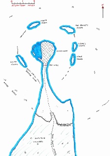
The peninsula is a narrow strip of land extending northward from the coast for approximately ten miles. At its narrowest point, it is barely more than 400 yards wide. The land is of solid granite that has withstood millennia of erosion by the sea.
The southern portion of the peninsula is highly fertile farmland and contains a small number of villages. North of this, a line of sheer cliffs extends the full width of the peninsula, rising to heights of between forty and fifty feet. In the approximate centre of this escarpment, a man-made cutting allows the Great North Road to continue at a shallow gradient towards Kingsmount.
North of the escarpment, the land is still grassy but the shallow, chalky topsoil makes it unsuitable for agriculture; sheep and goats are grazed here. The peninsula at this point is bounded by steep coastal cliffs up to 100 feet high on both the east and west sides. Caves in these cliffs lead to a network of tunnels of unknown extent that lie beneath the surface of the peninsula.
At the extreme north of the peninsula lies the city of Kingsmount, the oldest city in Atlantis.
The northern tip of the peninsula is surrounded by a number of small islands that form a rough arc around the city, lying one or two miles offshore. The main islands are: South Island, North Island, The Prince's Island, Drake's Island, and Stone Island. Lying between, and beyond, these islands are arcs of barely submerged rocks. These form a significant hazard to any ship attempting to enter the harbour at Kingsmount, making the position of Pilot one of the most important in the city.
During the war of 2350 (Atlantean Calendar), a stone wall was built across the peninsula at its narrowest point, intended to defend the city against invasion. The Great North Road passed through gates in the centre of this wall.
History
There are clues in ancient Atlantean writings that suggest the island of Atlantis was once twice its current size, and what remained during later Atlantean ages was merely the southern half of the original island, the northern half having vanished in some prehistoric catastrophe. An examination of the map of the peninsula will reveal clues that Kingsmount might once have been the centre of a volcanic caldera, with the circle of islands marking the rim. All this is entirely conjectural, however, and even the greatest Atlantean scholars did not know for certain.
