Egypt
Era
Egyptian (c. 1450 BCE).
Location
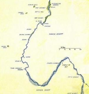
Egypt is a country in north Africa. This article is concerned with the region of Upper Egypt and Nubia between the confluence of the Blue and White Niles and the third cataract on the Nile, as it was in the historical period circa 1450 BCE.
Description
The region of Upper Egypt between the confluence of the Blue and White Niles and the third cataract on the Nile covered an area of 62,500 square miles (160,000 square kilometres), however most of that area was trackless, unexplored desert land. The Nile ran in a large "S"-shaped course between these two points. All settlements in the area were based on the banks of the Nile, the only place in those arid regions where life could survive.
At the third cataract, the Nile was half a mile (800m) wide, with fertile, irrigated land stretching over a mile on the western bank. The Nile was an important conduit for trade, but the third cataract, a stretch of shallow, white-water rapids, posed an almost impassable barrier. Thus the town of Hebenu, built just below (i.e. north of) the third cataract, was a vital trade centre. Goods from further south were portaged down the length of the cataract, to be loaded onto boats at the wharves of Hebenu and continue their journey to the more populous regions of the north.
Above the third cataract, the Nile ran in a curved course, eventually turning through 180 degrees to run north. At the point of the turn sat the small frontier town of Bayuda-Bar, a wretched hive of scum and villainy useful only as a good place to hire itinerant oarsmen for your journey.
Before turning south once again, the traveller up the Nile would encounter the fourth cataract, a much more formidable obstacle than the third as it included a high, plunging waterfall that no boat could pass over. At this cataract lay the settlement of Napata and the temple of Nut.
Beyond the fourth cataract, the terrain was unknown even to the Nubians. There were rumours of an ancient town at the Nile confluence, but very few tales of it passed into the northern lands.
Away from the Nile, the land on either side consisted of arid, rocky desert. The terrain was mostly flat, but ridges of low hills, along with sudden cliffs and deep gulleys, made navigation across it extremely difficult.
History
This period of Egyptian history has been called the New Kingdom, comprising the 18th, 19th and 20th dynasties of the Pharaohs, 1573–1085 BCE. In this period, Egyptian influence was extended for the first time to the lands beyond the fourth cataract, the farthest extent the Egyptian Empire ever attained. The history of this period is well documented in text books and it is not necessary to cover the subject in detail here, but there are a few points of relevance to our story which should be mentioned.
Tuthmosis I (1504–1492) is known for his outstanding military achievements. His empire reached the Euphrates in Mesopotamia and to the fourth cataract in Nubia. Tuthmosis I's daughter, Hatshepsut, was wife of Tuthmosis II and later the regent of Tuthmosis III (1479–1425), but proclaimed herself Pharaoh in 1473. During her reign, there was little military activity and Egypt lost much of its land in the Middle East. Most notably in her reign, however, a trading expedition was sent to the marvellous land of Punt, a land which was to take on mythical importance in later years.
After Hatshepsut's death, Tuthmosis III launched a long series of campaigns to reclaim lost territory in the Middle East. Over 20 years, the Egyptians fought mainly in Syria. It is this campaign that General Sabu fought in, and the extensive drain on resources explains why an important general had so few fighting men at his disposal in the garrison at the provincial capital of Hebenu.
Late in his reign, Tuthmosis III campaigned in Nubia and extended Egyptian dominance enough that the provincial capital was moved to Napata at the fourth cataract. This is after the period of our story, however. In the year 1450 (the 19th year of the reign of Tuthmosis III) the provincial capital was at Hebenu, just below the third cataract, and Napata was a small outpost notable only as the site of a temple dedicated to the goddess Nut. The land beyond the fourth cataract was still unconquered, untamed, and largely unknown at this time. Nekure was the governor and administrator of Hebenu and surrounding province, making him the ultimate authority in the region and answerable only to the Pharaoh.
People
The lands south of the third cataract were a meeting point of two different cultures, the Egyptians to the north and the Nubians to the south.
South of Hebenu, the country was populated mainly by Nubians, with very few Egyptians living among them.
Important Locations
- Hebenu, a town on the third cataract.
- Bayuda-Bar, a town between the third and fourth cataracts.
- Napata, a town on the fourth cataract.
- The temple of Nut, on the fourth cataract.
Notable Occupants
- Alex, a visitor from Minoa.
- Esther, a slave.
- Meriptah, high priest of Hathor
- Nekure, governor of Hebenu.
- Ptank, priest of Hathor, cousin to Nekure.
- S'Peok, Nubian warrior.
- General Sabu, garrison commander at Hebenu.
- Sit-Hathor, mercant of Hebenu.
- Yames, a visitor from the far north.
